


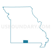
Bridges Voting District, Ozark County, Missouri
About
Outline

Summary
| Unique Area Identifier | 609294 |
| Name | Bridges Voting District |
| County | Ozark County |
| State | Missouri |
| Area (square miles) | 138.40 |
| Land Area (square miles) | 138.32 |
| Water Area (square miles) | 0.08 |
| % of Land Area | 99.94 |
| % of Water Area | 0.06 |
| Latitude of the Internal Point | 36.60477570 |
| Longtitude of the Internal Point | -92.42652620 |
Maps


Graphs
Select a template below for downloading or customizing gragh for Bridges Voting District, Ozark County, Missouri


Neighbors
Neighoring Voting District (by Name) Neighboring Voting District on the Map
- Voting District 2-1, Baxter County, AR
- Voting District 2-3, Baxter County, AR
- Barren Fork Voting District, Ozark County, MO
- Big Creek Voting District, Ozark County, MO
- Dawt Voting District, Ozark County, MO
- Jackson Voting District, Ozark County, MO
- Lick Creek Voting District, Ozark County, MO
- Pontiac Voting District, Ozark County, MO
- Richland Voting District, Ozark County, MO
Top 10 Neighboring County Subdivision (by Population) Neighboring County Subdivision on the Map
- Pigeon township, Baxter County, AR (1,850)
- Logan township, Baxter County, AR (1,566)
- West Bridges township, Ozark County, MO (1,242)
- Bridges township, Ozark County, MO (968)
- Richland township, Ozark County, MO (794)
- Jasper township, Ozark County, MO (703)
- Dawt township, Ozark County, MO (492)
- Barren Fork township, Ozark County, MO (443)
- Pine Creek township, Ozark County, MO (439)
- Lick Creek township, Ozark County, MO (434)
Top 10 Neighboring Place (by Population) Neighboring Place on the Map
Top 10 Neighboring Unified School District (by Population) Neighboring Unified School District on the Map
- Mountain Home School District, AR (33,097)
- Gainesville R-V School District, MO (4,526)
- Dora R-III School District, MO (1,843)
- Lutie R-VI School District, MO (1,635)
Top 10 Neighboring State Legislative District Lower Chamber (by Population) Neighboring State Legislative District Lower Chamber on the Map
- State House District 143, MO (38,454)
- State House District 81, AR (30,298)
- State House District 82, AR (28,911)
Top 10 Neighboring State Legislative District Upper Chamber (by Population) Neighboring State Legislative District Upper Chamber on the Map
Top 10 Neighboring 111th Congressional District (by Population) Neighboring 111th Congressional District on the Map
Top 10 Neighboring Census Tract (by Population) Neighboring Census Tract on the Map
- Census Tract 9508, Baxter County, AR (6,097)
- Census Tract 4702, Ozark County, MO (4,904)
- Census Tract 4701, Ozark County, MO (4,819)
Top 10 Neighboring 5-Digit ZIP Code Tabulation Area (by Population) Neighboring 5-Digit ZIP Code Tabulation Area on the Map
- 72653, AR (28,560)
- 65655, MO (3,186)
- 65760, MO (739)
- 65773, MO (711)
- 72623, AR (648)
- 65729, MO (264)
- 65618, MO (148)
- 65784, MO (34)